Laval’s growth from a patchwork of rural parishes on Île Jésus into Quebec’s third-largest city placed unique demands on its subsurface. The island’s geology, shaped by the Champlain Sea regression, left thick sequences of marine clay and till over fractured Ordovician limestone. When a new transit corridor or institutional building breaks ground in Chomedey or Sainte-Rose, guessing bedrock depth from sparse boreholes alone invites cost overruns. Our seismic tomography campaigns—both refraction and reflection—deliver continuous P-wave and S-wave velocity profiles that reveal the true rockhead topography, helping engineers size excavations and select foundation types with confidence. For deeper targets, we often pair a CPT test campaign with the tomographic model to calibrate soil stiffness where the velocity contrast between clay and till is subtle but mechanically critical.
Seismic tomography turns a few borehole data points into a continuous image of the subsurface, reducing the uncertainty that drives up contingency costs on Laval projects.
Local considerations
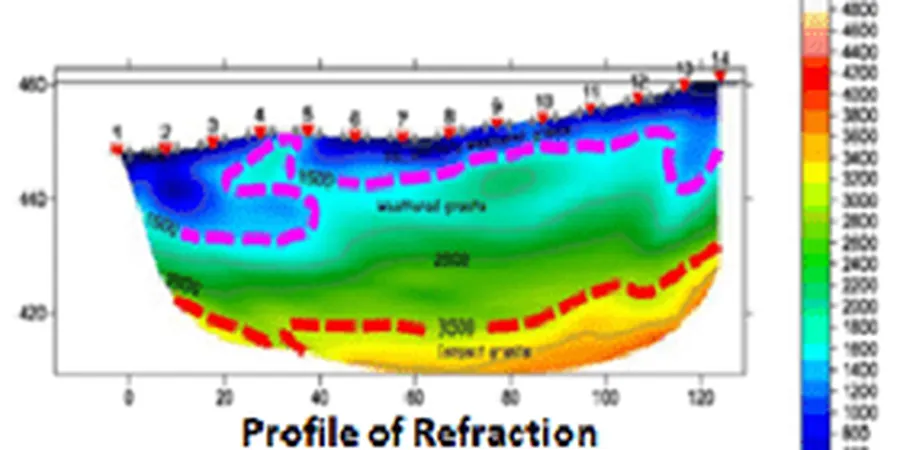
At 45.5571° N, Laval sits within the Western Quebec Seismic Zone, where magnitude 5+ events occur roughly once per decade. The 1732 Montreal earthquake, estimated at M5.8, caused significant damage on Île Jésus, and modern NBCC 2020 maps assign the region a site class C to E depending on soil thickness. Seismic tomography provides the Vs30 profile needed to assign the correct site class and avoid over-conservative or unconservative spectral accelerations. Beyond earthquake design, Laval’s average elevation of 40 masl means that buried valleys filled with compressible Champlain Sea clay are common, and missing a deep trough under a proposed high-rise in the Centre-Ville district could trigger differential settlement and costly underpinning. Tomographic sections across these valleys let the structural team place deep foundations only where the bedrock drops, rather than over the entire footprint.
Applicable standards
ASTM D5777-18, NBCC 2020 (Division B, Part 4, Seismic Hazard), CSA A23.3-19 (concrete structures, seismic provisions), BNQ 2501-092 (geotechnical site investigation, Quebec context)
Frequently asked questions
How much does a seismic tomography survey in Laval typically cost?
Depending on the array length, source type, and whether both refraction and reflection are required, a typical survey on Île Jésus falls between CA$3,230 and CA$6,570. Projects needing crosshole logging or very deep penetration may exceed this range, and we provide a fixed-price proposal after reviewing the site geometry.
What is the difference between refraction and reflection tomography?
Refraction tomography uses the first-arrival times of seismic waves that travel along the interface between soil and rock, building a velocity model of the subsurface that works best when velocity increases with depth. Reflection tomography stacks later-arriving energy to image interfaces where velocity may decrease, such as fracture zones or cavities, giving a more detailed structural picture of the rock mass.
Can seismic tomography replace boreholes for site investigation in Laval?
It complements boreholes rather than replacing them. Tomography provides continuous lateral coverage between discrete drill points, reducing the number of boreholes needed, but a few calibration boreholes remain essential to tie velocity values to specific lithologies and to sample the clay for laboratory testing.
How long does a seismic tomography campaign take on a typical Laval site?
A single refraction line of 115 metres with 24 geophones can be acquired in about two hours, and processed data delivered within three to five business days. Larger grids or reflection spreads require proportionally more field time, but most commercial lots in Laval are covered in one or two field days.
Is seismic tomography feasible in winter conditions on Île Jésus?
Yes, winter surveys are common in Laval. Frozen ground actually improves geophone coupling and reduces surface-wave noise, though the frozen surface layer must be accounted for in the velocity model. We use heated battery packs and low-temperature cabling rated to -30°C for reliable winter acquisition.