Laval sits at a modest 91 meters above sea level, yet the real variation that matters for seismic safety lies in its subsurface. The 1988 Saguenay earthquake—magnitude 5.9, felt strongly here—reminded engineers that eastern Canada's intraplate seismicity cannot be dismissed. On Île Jésus, post-glacial Champlain Sea clays blanket large sectors, while compact glacial till emerges near the Rivière des Mille Îles. A standard borehole alone won't give you the continuous shear wave velocity profile you need for NBCC 2020 site classification. That's where MASW (Multichannel Analysis of Surface Waves) comes in: a non-invasive survey that maps Vs30 across the site, pinpointing transitions from soft clay to stiffer lodgement till. When the stratigraphy is erratic—and in Laval, it often is—combining MASW with a seismic microzonation study clarifies how basin-edge effects might amplify ground motion in the western districts, or how a buried esker ridge under Chomedey changes the site period.
Champlain Sea clay in Laval can shear at strains below 1%, making Vs30 the critical parameter for avoiding Class E penalties in the structural design.
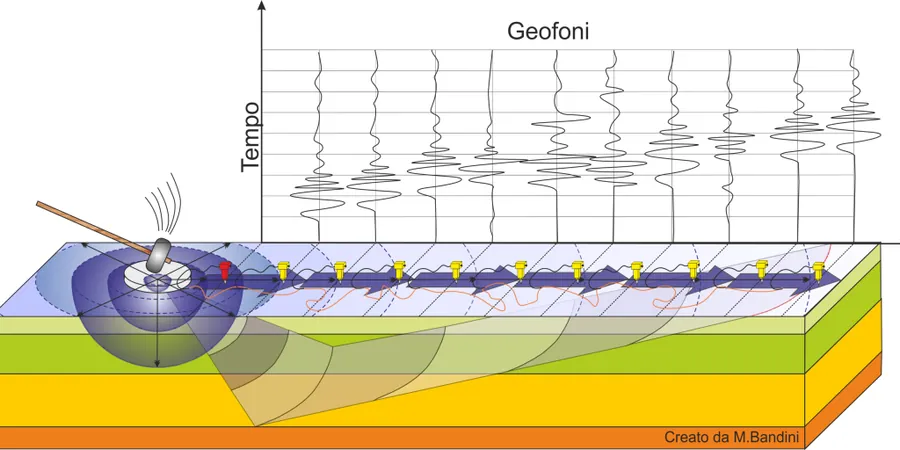
Methodology and scope
Compare the terrain in Sainte-Dorothée with that in Duvernay and the difference is stark. Sainte-Dorothée sits on thick, sensitive marine silts that lose strength when disturbed; Vs30 values there can dip below 180 m/s, pushing the site toward Class E. Duvernay, by contrast, rests on a shallow till veneer over limestone bedrock, producing Vs30 readings often above 400 m/s—a firm Class C profile. MASW lets you map this lateral change without trenching or drilling across the property. The method uses a 24- or 48-channel seismic cable, a sledgehammer or weight-drop source, and inversion software that derives a 1D shear wave velocity column from the dispersion curve. Because the survey is surface-based, access is straightforward even on congested industrial lots in Laval's Autoroute 440 corridor. For sites where deeper bedrock confirmation is needed, we pair the surface wave data with a
seismic refraction line to resolve the top-of-rock geometry, and where pile design depends on lateral soil stiffness, a
CPT test provides continuous tip resistance and sleeve friction to calibrate the velocity profile against in-situ strength.
Frequently asked questions
What does a MASW survey cost for a typical Laval residential lot?
For a single-family or duplex lot on Île Jésus, a MASW survey with two to three array positions and a signed NBCC site-class letter typically runs between CA$2,070 and CA$4,620, depending on access conditions and whether supplementary seismic refraction lines are needed to confirm bedrock depth.
How does MASW handle the Champlain Sea clay that is common in Laval?
Champlain Sea clay presents a strong velocity contrast with the underlying till or bedrock, which actually helps the Rayleigh-wave dispersion curve pick up the interface clearly. The challenge is the clay's low shear modulus at small strains; we use a 2-Hz geophone array and a heavy source (accelerated weight drop) to generate enough low-frequency energy to resolve the full 30-meter column. The inversion is constrained with any available borehole log to avoid the non-uniqueness problem in soft-soil profiles.
Is MASW accepted by Laval building officials for seismic site classification?
Yes. The City of Laval's building department accepts MASW-derived Vs30 values for NBCC 2020 site classification when the survey is conducted under the direct supervision of a Professional Engineer licensed by the Ordre des ingénieurs du Québec. The report must include raw shot gathers, dispersion curves, and the inversion model, not just the final Vs30 number. For Part 4 buildings, we also reference the CSA A23.3-19 seismic provisions in the engineering letter.